
The science of rainbows, nature’s prism of color
ST. JOSEPH, Mo. (News-Press NOW) — Rainbows are often seen as symbols of luck, and if you spot one, consider yourself lucky.
Continue Reading ST. JOSEPH, Mo. (News-Press NOW) — Rainbows are often seen as symbols of luck, and if you spot one, consider yourself lucky.
Continue Reading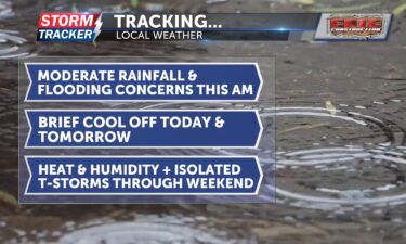
Tracking moderate rainfall and flooding concerns this morning: late-week cool down
Continue Reading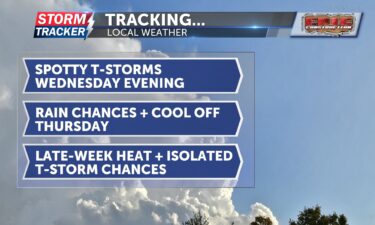
A hot and muggy Wednesday afternoon will give way to a round of scattered t-storms across Northwest Missouri and Northeast Kansas Wednesday evening and overnight. Locally heavy rainfall and gusty winds could accompany any storms that form, otherwise garden variety activity is expected.
Continue Reading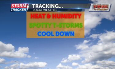
Tracking summer heat and multiple chances for thunderstorms today
Continue Reading
Tracking mid-week heat and humidity along with spotty t-storm chances.
Continue Reading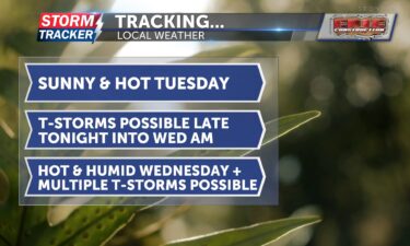
Tracking another hot day: scattered storms possible late tonight and Wednesday
Continue Reading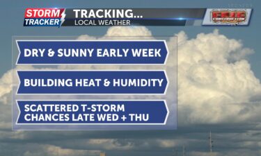
Hot and sunny afternoons will prevail across Northwest Missouri and Northeast Kansas through the start of the work week.
Continue Reading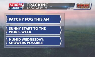
Tracking a hot and sunny start to the work-week
Continue Reading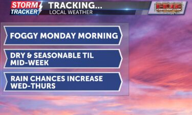
Clear and warm weather continues through Monday, with fog possible in the morning, before rain and storms move in midweek—especially Wednesday and Thursday—followed by a quick return to dry, hot conditions by the weekend.
Continue Reading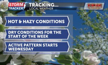
Canadian wildfire smoke will continue to impact air quality with hazy skies overnight, a slight chance of sprinkles through the weekend, warming temperatures into next week, and increasing rain chances by midweek.
Continue Reading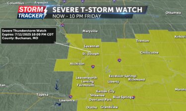
A Severe Thunderstorm Watch has been issued for much of Northwest Missouri and Northeast Kansas through 10 p.m. Friday.
Continue Reading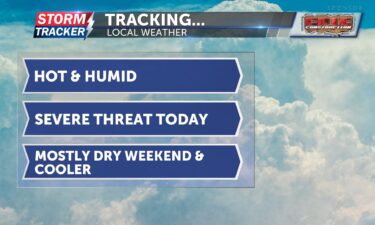
Tracking scattered severe threat this evening: cooler, mostly dry weekend ahead
Continue Reading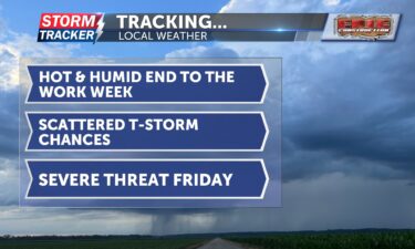
Hot and muggy conditions will be accompanied by scattered t-storm chances to finish out the work week across Northwest Missouri and Northeast Kansas. A threat for strong storms is forecast to develop late Friday afternoon and evening.
Continue Reading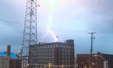
Cloud-to-ground lightning strike in downtown St. Joseph during an afternoon thunderstorm in August of 2023.
Continue Reading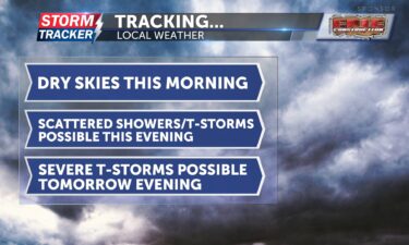
Tracking spotty showers this evening; severe storm risk increases tomorrow
Continue Reading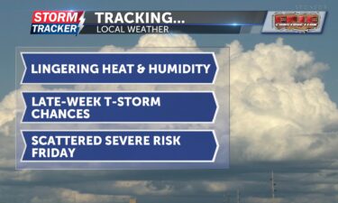
Hot and muggy summer air will remain in place across Northwest Missouri and Northeast Kansas through the work week, fueling isolated t-storms chances Wednesday night and Thursday.
Continue Reading
ST. JOSEPH, Mo. (News-Press NOW)– Over the past month, the Storm Tracker weather team has worked diligently to prioritize community safety and education.
Continue Reading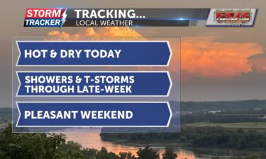
Tracking dry skies today: late-week showers and thunderstorms possible
Continue Reading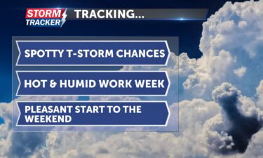
Tracking spotty t-storm chances, heat, and humidity through the work week.
Continue Reading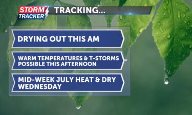
Tracking lingering showers this morning, July heat, and possible late-week thunderstorms
Continue Reading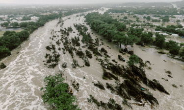
ST. JOSEPH, Mo. (News-Press NOW) –The death toll in Texas continues to rise after deadly flash flooding turned what was meant to be a celebratory holiday weekend into a devastating and life-altering event.
Continue Reading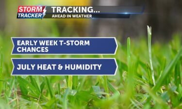
Isolated to scattered t-storm chances, and July heat will continue across Northwest Missouri and Northeast Kansas to start the work week.
Continue Reading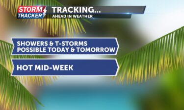
Tracking hot and stormy start to the week
Continue Reading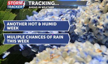
Hot and humid through the week with isolated rain Monday, heavier storms Tuesday, and cooler temps by Saturday.
Continue Reading
Widely scattered thunderstorms will continue to fire across parts of Northwest Missouri and Northeast Kansas Saturday afternoon and evening, as a front passes through the region. A few storms may produce gusty winds, heavy rain, and small hail. Partly cloudy skies, and a 40% chance of t-storms will linger into the overnight hours, with mid
Continue Reading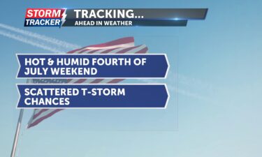
Seasonably hot and humid conditions will remain across Northwest Missouri Northeast Kansas through Independence Day weekend, with increasing chances for scattered t-storms by Saturday.
Continue Reading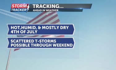
Tracking a seasonable Fourth of July: strong, scattered storms possible tomorrow
Continue Reading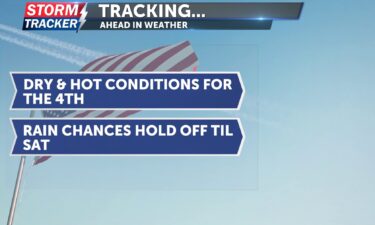
Tracking a hot and humid Independence Day with highs in the 90s, a slight chance of showers Friday, increasing rain chances Saturday with a cooling trend into the weekend.
Continue Reading
America’s holiday: Fourth of July climatology and why firework smoke lingers
Continue Reading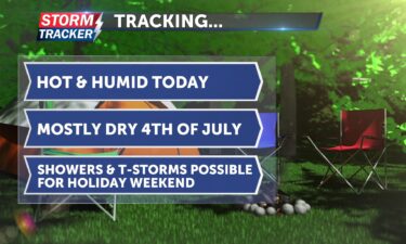
Tracking a hot and humid late-week: showers possible through holiday weekend
Continue Reading