Texas flooding causes a wake-up call for local preparedness
ST. JOSEPH, Mo. (News-Press NOW) --The death toll in Texas continues to rise after deadly flash flooding turned what was meant to be a celebratory holiday weekend into a devastating and life-altering event.
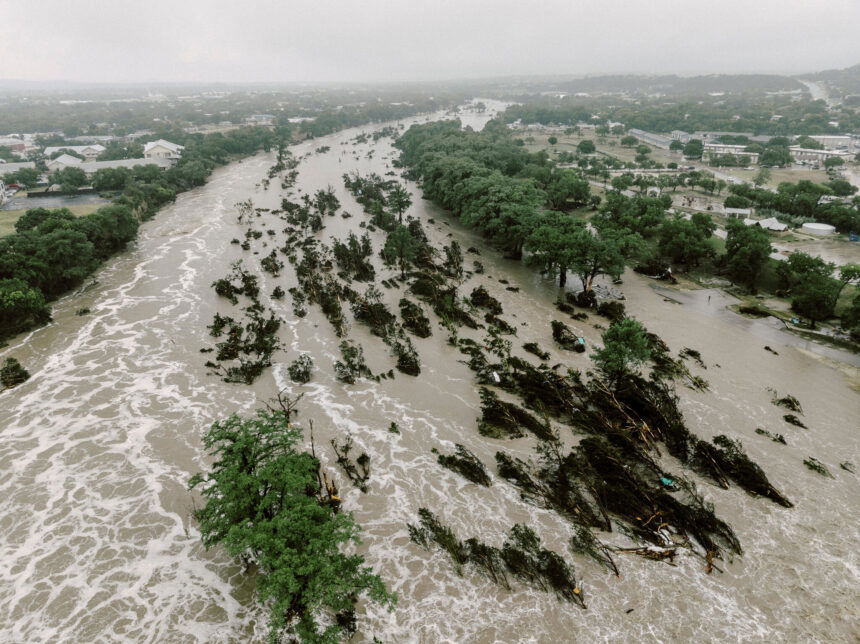
In the Texas Hill Country, more than 20 inches of rain fell in a short period, causing the Guadalupe River to rise 26 feet in under an hour.
The National Weather Service (NWS) office in San Antonio worked to communicate the severity of the incoming weather. Despite their efforts, many residents did not receive or hear the warnings in time.
According to the NWS website, forecasters began highlighting the potential for heavy rainfall as early as Sunday, June 29.
By Tuesday, July 1, the forecast included warnings about the risk of dangerous flooding due to excessive rainfall. On Thursday, July 3, at 1 p.m., a flood watch was issued for a large portion of the Texas Hill Country.
Just after midnight on Friday, July 4, an additional flash flood watch was issued for Kerr County, warning that rainfall totals could exceed 10 inches.
Less than an hour later, a flash flood warning was issued due to life-threatening conditions.
These alerts continued throughout the early morning hours and ultimately escalated into a flood emergency.
While this tragedy happened in Texas, it’s a sharp reminder that flooding can happen quickly and without much warning — even in our local communities.
It’s important to understand the flood-prone areas in your neighborhood and be aware of nearby rivers and streams that are likely to overflow during heavy rain.
Throughout the St. Joseph area, city officials are continuing to implement preventative measures to help combat flash flooding in the local area.
Colleen Armstrong from the City of St. Joseph's stormwater department explains that putting detention systems in place will help with stormwater flooding.
"Put in stormwater controls, whether those are basins, rain gardens, or underground stormwater detention to help hold back that peak flow during a heavy rain event," said Armstrong.
Beyond knowing which areas are most vulnerable, it’s critical to have multiple ways of receiving weather alerts — especially at night. A NOAA weather radio or the Storm Tracker Weather App can help ensure you stay up to date with watches and warnings specific to your location, even while you sleep.
Scott Watson, chief hydrologist at the NWS, said it's common for people to believe severe weather won't affect them. This is when tragedy can strike—people may go to sleep unaware of the situation unfolding outside.
"Most people don't think it's going to affect them," said Watson. "Then there's some people that just, you know, they're not paying attention to what the weather forecast is."
If you find yourself in a situation where floodwaters are rising, take immediate precautions. Always remember the phrase: "Turn Around, Don’t Drown." Move to higher ground as quickly as possible, and never try to outrun or drive through floodwaters. As little as two feet of moving water can sweep away a vehicle or knock a person off their feet.