US and India launch historic joint mission that could change the way we see Earth
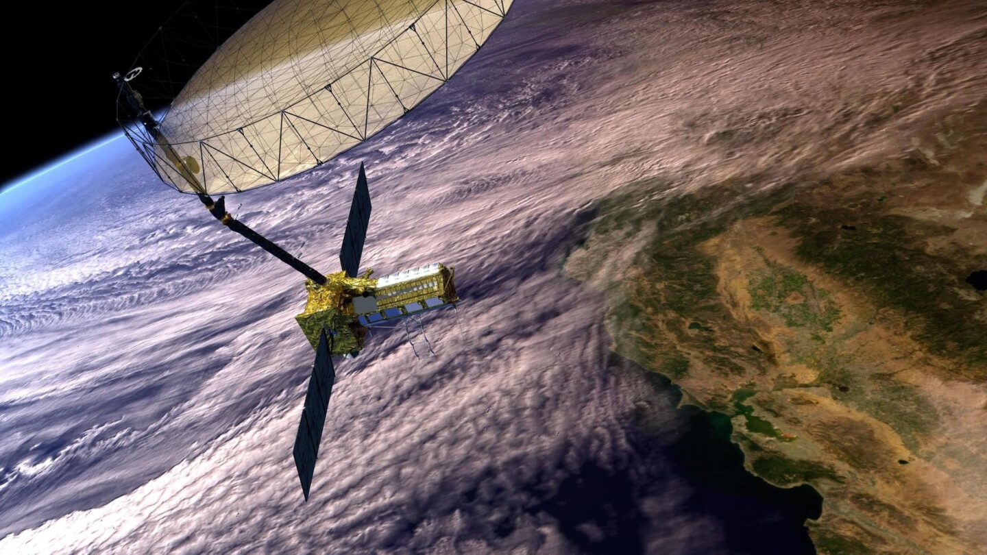
NISAR lifted off from India on July 30.
By Ashley Strickland, CNN
(CNN) — A first-of-its-kind satellite has launched to track nearly imperceptible changes on Earth’s surface, an effort that could aid with responses to natural disasters.
Called the NASA-ISRO Synthetic Aperture Radar mission, or NISAR, the spacecraft is equipped with two kinds of synthetic aperture radar designed by the US space agency and the Indian Space Research Organization in the countries’ first joint satellite project.
The radar, pioneered by NASA to use in space, works like conventional radar in that it uses microwaves to detect distant surfaces and objects. But advanced data processing enables the details to be seen at high resolution.
NISAR lifted off from Satish Dhawan Space Centre on India’s southeastern coast at 8:10 a.m. ET (5:40 p.m. IST) Wednesday aboard an ISRO Geosynchronous Satellite Launch Vehicle, or GSLV-F16. The launch was streamed live on NASA+ and the agency’s YouTube channel.
The satellite will orbit Earth 14 times per day in order to complete scans of almost all of the planet’s ice and land surfaces twice every 12 days, detecting changes in Earth’s surface down to fractions of an inch in the process.
NISAR’s dual radar will collect information that could allow for a better understanding of landslides and earthquakes, and improve the monitoring of ice sheets, glaciers, permafrost, forests, wetlands and agricultural fields. The data, which will be publicly available as it is collected and downloaded from the satellite, will also be used to prepare for and respond to hurricanes, volcanic eruptions, flooding and wildfires.
The mission, first proposed in 2014, will allow scientists to monitor Earth like never before, changing the way we study our home planet and better predicting a natural disaster before it strikes, said Nicky Fox, associate administrator for NASA’s Science Mission Directorate.
“Even though we may not always notice it, much of our Earth’s land surface is in constant motion,” Fox said. “The changes, however, are so subtle that right now they’re virtually undetectable. The need to be better prepared before, during and after the challenges caused by natural disasters around the world could not be greater.”
Monitoring the planet
NISAR, which is about the length of a pickup truck, is expected to capture a broad range of information due to its dual radar system — an L-band system with a 10-inch (25-centimeter) wavelength, and an S-band system with a 4-inch (10-centimeter) wavelength. The L-band was provided by NASA’s Jet Propulsion Laboratory (JPL) in Pasadena, California, while the S-band was supplied by ISRO.
“NISAR is an equal 50/50, partnership between NASA and ISRO,” said Wendy Edelstein, NISAR deputy project manager at NASA’s JPL, during a July 21 news conference. “These two radars work together to achieve science that neither could see on their own.”
The signal of each system is calibrated to features of different sizes on Earth. Shorter wavelengths in the S-band can measure small objects, like leaves and the roughness of surfaces, to monitor crops, while long wavelengths in the L-band can peer through thick tree canopies to study forest structure and even spot boulders and tree trunks. The radar systems can also take specific measurements of motion, land deformation and moisture content.
By bouncing microwave signals off Earth’s surface and receiving return signals on a large radar antenna reflector, NISAR will be able to see through clouds and rain during the day and at night. The satellite’s continuous observation could spot potential land movement before a volcanic eruption, or help scientists understand how motion on Earth’s surface could disrupt infrastructure like levees or dams. It could even provide insights about where earthquakes may occur, according to NASA.
A mission powered by collaboration
The satellite is the result of conversations between NASA and ISRO that began in response to the National Academy of Science’s 2007 decadal survey, which identified research priorities and recommended prioritizing observations of Earth. The two agencies signed an agreement on September 30, 2014, to partner on the NISAR mission.
In addition to providing the S-band radar, ISRO is calibrating the instrument, processing its data and developing algorithms to achieve the scientific goals of the mission. The agency has also supplied the body of the satellite, the launch vehicle and launch services. Meanwhile, NASA contributed a radar reflector antenna, a deployable boom, a communication subsystem for incoming data and other aspects of the spacecraft.
“We are two nations with one mission,” said Karen St. Germain, director of Earth science at NASA, during a recent news conference. “NISAR unites the US and India to study our home planet together. The collaboration, cooperation and information sharing between our two agencies is a foundation that we really look forward to continuing to build upon.”
Previously, some NASA instruments were flown aboard India’s first deep-space mission Chandrayaan-1, which launched in 2008 and orbited the moon for nearly two years.
Together, members of the NASA and ISRO team collaborated across 13 time zones and more than 9,000 miles (14,500 kilometers) to work on NISAR, requiring long-distance travel and many late-night and early morning video calls to build and test systems. The hardware was assembled on two different continents before being integrated in India to complete the satellite.
Edelstein has traveled to India more than 25 times over the past decade and spent more than 150 days over the last two years working alongside team members at ISRO. Traveling from JPL, it took her 36 hours, door to door, to reach Bengaluru, India, where the systems were being tested. But she said the journey has allowed her to get to know her colleagues at ISRO well and be immersed in Indian culture — something she calls a very big personal highlight.
St. Germain agrees: “Building a satellite on opposite sides of the world during a global pandemic was really hard, but it strengthened our relationship with ISRO,” she said.
Dr. Jitendra Singh, India’s Minister for Science and Technology, said the mission is in line with Prime Minister Narendra Modi’s vision for India to become a “Vishwa Bandhu,” or a global partner that contributes to the collective good of humanity, according to a news release shared by the country’s Press Information Bureau.
“This mission is not just about a satellite launch — it is a moment that symbolises what two democracies committed to science and global welfare can achieve together. NISAR will not only serve India and the United States but will also provide critical data for countries around the world, especially in areas like disaster management, agriculture, and climate monitoring,” Singh said. “NISAR is not just a satellite; it is India’s scientific handshake with the world.”
The-CNN-Wire
™ & © 2025 Cable News Network, Inc., a Warner Bros. Discovery Company. All rights reserved.


