‘Eyes in the sky’: Task Force 1’s drones prove effectiveness for agencies across the state
Nia Hinson
COLUMBIA, Mo. (KMIZ)– St. Louis Fire Chief Dennis Jenkerson will never forget May 16, 2025.
It was a Friday around 3:15 p.m., meaning major roads in the city were already packed with traffic as rush hour approached. That would lead to even more issues down the road.
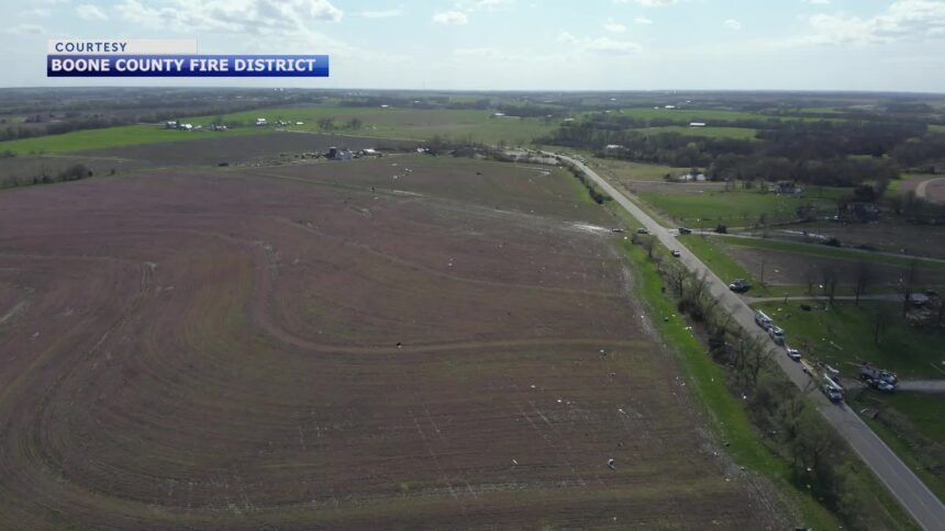
It was the day an EF-3 tornado struck the city of St. Louis and parts of St. Louis County, killing five and leaving behind miles of destruction.
Jenkerson said the tornado tore through the central and north-central sections of the city and was on the ground for roughly 8 miles. The storm was anywhere from a mile to three-quarters of a mile wide and took out electrical substations, affecting between 8,500 and 10,000 homes before it crossed the river into Illinois.
As if the thought of rescue efforts wasn’t enough for first responders to ponder, they now had to deal with the issue of getting equipment into the affected areas because of congestion on major roads.
“It was established fairly early on that this was a major event, that we had multiple homes involved. It kind of clipped the corner of where one of our major hospitals was located,” Jenkerson said.
That hospital was the Barnes-Jewish Hospital, along with the children’s hospital.
The St. Louis-area responders needed help. Missouri Task Force 1 — an urban search and rescue team based at the Boone County Fire Protection District headquarters in Columbia — was among the five agencies that answered the call during the 72-hour search.
Fearing mass casualties
Jenkerson said a little more than half of Kingshighway in the city limits, up to about Delmar Boulevard, was impassable at the time. That, along with major destruction to buildings that they could see from the ground, led emergency responders to think they were looking at a mass casualty event.
“So, the call was made out to Region C, which I’m the co-director in the state of Missouri, that we were going to need the task forces as soon as possible and to notify Missouri Task Force 1,” Jenkerson said. “Based on the radio reports we were getting from our dispatch center for calls for assistance, we had a very wide section of the city that was in need of immediate emergency response.”
Missouri Task Force 1 arrived in St. Louis around midnight and immediately got to work.
Jenkerson said they had already searched about 2,500-3,000 buildings within the first 24 hours of their response, thanks in part to Missouri Task Force 1’s manpower and equipment. But it was one small piece of equipment that proved vital during while saving people who were trapped: the drone.
“Immediately, we were probably looking at 12 or 15 to 20 areas that concerned us,” Jenkerson said. “A couple big churches, a couple commercial buildings, quite a few residential structures. And the drones gave us the ability to get a quick overhead look at what we were searching, how big the area was.”
Jenkerson said the drones helped emergency responders with their operational plan as they entered buildings. He said responders not only had to be worried about entering collapsed buildings, but also about the structural soundness of surrounding buildings.
The drones also allowed them to see what areas were stable and which areas were not, as they continued the process of delayering and digging down to people who were trapped.
Jenkerson said he flew over the area in a helicopter early on after the storm. However, being able to physically move the drones around near possible areas of entrapment and having an extra pair of eyes in the sky made all the difference.
“It just gives you a little more speed to get at buildings, but it gives you another set of eyes from a position that you normally can’t get eyes on,” Jenkerson said.
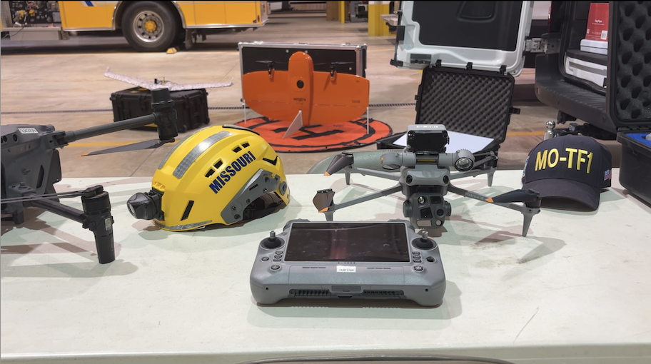
Jason Warzinik is Missouri Task Force 1’s technical information specialist and is the manager of the group’s Disaster Situation Awareness and Reconnaissance Team. He comes up with all of the training and leads the teams out in the field.
Warzinik said he believes the drones were highly effective during their deployment to St. Louis.
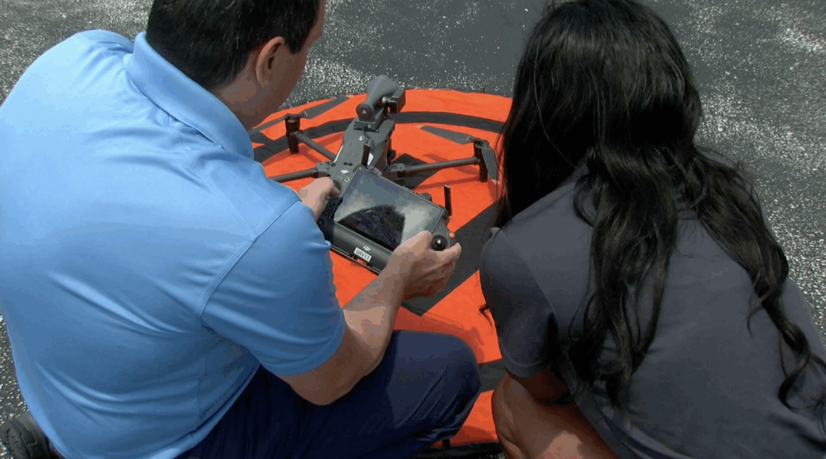 Jason Warzinik demonstrates one of the many capabilities of Missouri Task Force 1’s drones. (KMIZ)
Part of that was the ability to stream live drone video that night to the incident command. The next morning, crews were able to go out into the hardest-hit areas.
“Then, throughout those next two days, we had our areas that we were assigned,” Warzinik said. “But then of course when you get to the edge of your area, you’re doing a 360 kind of pan and based on those, it was pretty quick where incident command was going, ‘Hey, we need to go across that area, make a new assignment up to that path of that tornado.”
Task Force 1’s drones have helped other agencies, too.
In Mid-Missouri, Cooper County Emergency Management director Larry Oerly remains grateful for Missouri Task Force 1 more than two months after an EF-2 tornado struck Pilot Grove. The tornado was on the ground for about 5 miles and packed winds up to 135 mph.
Oerly said the county immediately started receiving reports from police and ambulance crews about damage and power lines down. During that time, Oerly said a determination was made that it was going to be an extended event.
He then made calls to the State Emergency Management Agency and eventually reached out to Missouri Task Force 1 for help. The Cooper County Sheriff’s Office had deployed its drones in the response, but they didn’t prove to be enough.
That’s where Missouri Task Force 1 came into play.
“Their drones are much more advanced than the ones we have,” Oerly said. “The drone can see things from the air that we can’t see from the ground. If there would have been maybe a body or something laying in a field or something, they could pick that up. Foot search would take forever to do that.”
How drones help local law enforcement and firefighters
It was about 7 p.m. on May 2, a Friday. Several law enforcement agencies gathered around a monitor and a vehicle on East Prathersville Road for hours. They were searching for two youths who had escaped from the Juvenile Justice Center. One of the two was being detained for murder, the other on a first-degree assault charge.
Law enforcement had searched the heavily wooded area and field after the two escaped on foot.
After hours of searches by the Boone County Sheriff’s Office, Columbia Police Department and the Missouri State Highway Patrol, the last youth was found just before 10:30 p.m. That was thanks to a drone provided by Missouri Task Force 1.
The drone was able to pick up a “heat signature” from the juvenile, which led law enforcement to locate him about 30 feet high in a tree.
Brian Leer with the Boone County Sheriff’s Office said he thinks more fugitives would get away if it weren’t for the help of the drones.
“I’d just be guessing the percentage, but I’ve seen these drones help us find people that, in my mind, I go home and I think, ‘I don’t know that we would have found them had it not been for their drone,’” Leer said.
The vehicle belonged to Missouri Task Force 1, as well as the monitor. The screen allowed law enforcement to see what the drone saw in the woods. Leer said the technology was “instrumental” in the search.
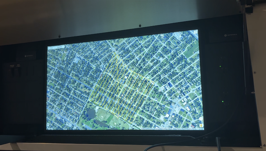 A photograph of one of the large screens on one of Missouri Task Force 1’s vehicles. (KMIZ)
The drones are also useful during searches for missing people or in vehicle crashes when it’s believed someone has been ejected. Drones can see locations that are inaccessible to humans. GPS capabilities and the ability to see in the dark make them key.
The drones are also used in responses to wildfires and structure fires to determine where there’s potentially still fire or excessive heat, Boone County Fire Protection District Chief Scott Olsen said. They can also assist local law enforcement by flying into homes to locate potential suspects.
Olsen said he believes all drones are effective, but Task Force 1’s many pilots and variety of drones are what make them different.
“We’ve done a lot of training together with the existing drone pilots and other agencies, so a lot of times we get called because they need just additional resources, and we wouldn’t hesitate to call them if we need additional resources on something that we’re doing,” Olsen said.
Missouri Task Force 1 began flying drones in 2017. The district has roughly 30 drones, along with 30 pilots.
Since Jan. 1, the task force has hosted four training events and responded to five local fire and mutual aid callouts, as well as five severe weather deployments. All of that together adds up to a total of 240 flights, with an air time of 43 hours, 11 minutes and 16 seconds for a total distance flown of 348 miles.
In 2017, the task force received $10,000 in state funding to launch a course on safe drone operations. Initial funding that year also included $65,000 to build a GIS-equipped vehicle from an existing fire district command vehicle.
The task force received additional funding from the state over the years since then to create additional vehicles and expand training efforts. Another $302,000 was allocated to the team from the state this year to purchase equipment, software and to further team development, according to Warzinik.
The drones come in varying sizes and are quadcopters. They have a flight time of roughly 40 minutes. The largest drone is used for overwatch and has live streaming capabilities. The drone has a speaker, spotlight, superzoom and thermal capabilities that allow it to operate at night.
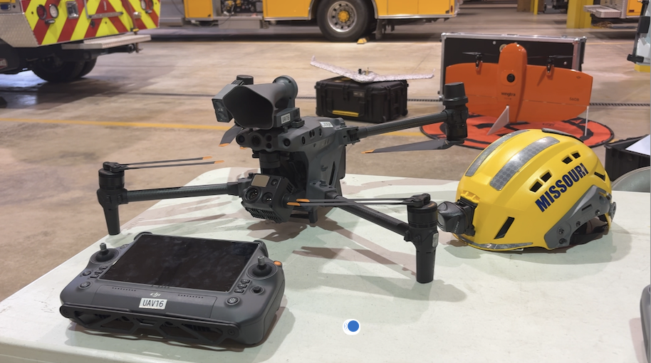 Missouri Task Force 1’s largest drone
 Missouri Task Force 1’s medium sized drone
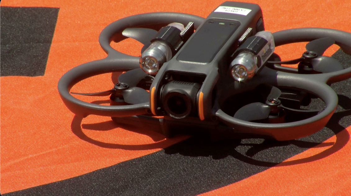 Missouri task force 1’s interior drone
A rangefinder allows pilots to zoom in on something and drop a pin on a map without having to fly the entire drone to the area.
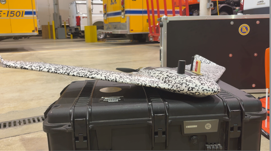
The medium-sized drone is geared towards mapping and was used in the St. Louis storm response, after being purchased just two weeks earlier.
The task force’s smaller interior drones come in handy during structural collapses. They have lighting that allows pilots to see inside dark buildings. Pilots have to use first-person goggles when flying this type of drone, and can then view what the drone sees from a screen.
“For example, if its a hazmat situation, we’ll have the hazmat tech from the task force watch that screen, get the lay of the land … figure out the floor plan … look for hazards and then they know, ‘Hey, when we suit up we need to take A, B and C inside so they’re not walking in blind,’” Warzinik said.
Warzinik said the interior drones cost roughly $600, while some of the fixed wings can cost up $40,000 because of pricey thermal and mapping sensors.
The task force also has technology that allows pilots to see when other drones or aircraft are flying in an area.
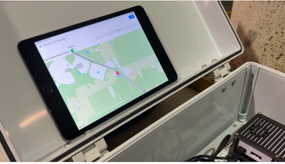 This tablet demonstrates how the task force can view other aircraft in the area during a deployment. (KMIZ)
Missouri Task Force 1 also has two different types of fixed-wing drones. These sorts of drones have a flight time of 60 to 90 minutes. They can be useful when they need to map larger areas, like the path of a tornado or hurricane, and can map in two dimensions or three.
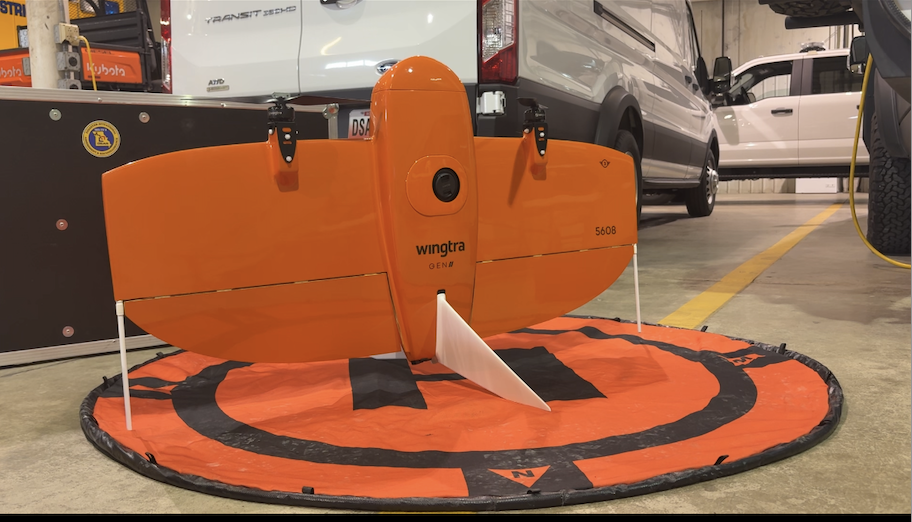 One of the task force’s “Fixed Wing” drones
 A second “Fixed Wing” drone
One can be programmed to fly over an area and take photos that the task force can stitch together.
The task force also has two vehicles designed specifically for drone and geographic information system work. The vehicles allow them to take data from the drones and upload the data online through a system called Starlink.
That data is then uploaded online to a central system called SARCOP. This allows photos and mapping layers to be uploaded online, where incident command, SEMA and the White House can view them.
The vehicles are equipped with a camera that can be used during the day or at night, two large-format printers for printing maps and radios for communicating with local and federal agencies.
“It was not too many years ago where our map that we would get is literally stopping by Sam’s Club and getting the map book out of Sam’s Club and taping it together,” Warzinik said. “Now, you look at what we can produce inside of that truck, almost live images of the impacted area.”
 A look inside one of Missouri Task Force 1’s vehicles that allows them to upload data from the field. (KMIZ)
The task force also has pickup trucks designed specifically for drone squads. The trucks also allow pilots to upload data quickly from the field.
That is also where live streaming platforms are used. Operators will hook up the drone’s controller to the truck’s monitor, allowing law enforcement and other agencies to see what the drone sees.
“The live feed was used throughout the event. It gave the incident commanders, who most of them were back at the command post, an idea of what was going on in the neighborhood,” Jenkerson said. “It’s like I said, any information you can add to the overall plan while it’s in operation gives you a better handle on what you’re doing of your search pattern.”
The future of drones and public safety
Missouri Task Force 1 is hoping to expand its use of drones.
Olsen said the task force isn’t able to fly its own drones when deployed on federal disasters. That included a recent trip to North Carolina, where the task force was sent for several days after Hurricane Helene.
Olsen said while there, the task force had to use other agencies’ drones. They’re working with FEMA to fly their own drones during federal deployments. A decision could come this month.
Olsen said his passion for wanting to expand how the drones are used stems from Hurricane Katrina in 2005. He said he was one of five people who had to go into New Orleans and set up for urban search and rescue teams.
Olsen said at the time, they made maps by hand and received Excel spreadsheets from police listing people who were trapped. He then started learning how to use some of the task force’s GIS capabilities to download data and make a map to show teams where trapped people were.
Olsen said searchers immediately found about 25 people within areas they had already searched.
“So, I saw the utility of this sort of system to be able to No. 1, get drones out and find out where people are and get aerial imagery to see what’s actually going on in the area. And then secondly, to take that information and marry it with data that we were getting to be able to find people more quickly,” Olsen said.
The Boone County Sheriff’s Office has about seven drones, Leer said. He said the sheriff’s office drones are also used in vehicle crashes and in outdoor homicide investigations.
The Columbia Police Department has five drones. Digital forensic specialist Chad Craig said the drones are typically used to monitor large events, like parades in the city, or for finding missing children.
“The use of drones at CPD is still growing,” Craig said. “I mean, we’re still in our infancy stage of trying to see how best to use, both for documentation, for real-time information and for assisting patrol operations and that kind of thing.”
Jenkerson said his fire department would love to expand its drone fleet.
“Any department in the state of Missouri is not going to handle this [tornado] by themselves, so having a regional asset, if you will, to come in and be on the ground within 24 hours, which they did, kind of allows you a little bit of room not to have every toy that you want,” Jenkerson said. “Drones that are made for hazardous material response, drones that are made for large-scale incidents like this, there’s always room for it and it’s something we’re looking at.”
Click here to follow the original article.


