Primetime hurricane season is here, and the Atlantic is a powder keg
There are two areas to watch for tropical development this week in addition to Tropical Storm Dexter
By CNN Meteorologist Briana Waxman
(CNN) — Atlantic hurricane season is about to hit its stride. August through mid-September is historically the most active stretch of the season, and while there have been a handful of short-lived named storms, the Atlantic has yet to spawn a hurricane in 2025.
That could change soon: Tropical Storm Dexter formed on Sunday night, churning far off the coast of the United States and well northwest of Bermuda. There are two other areas the National Hurricane Center marked for possible tropical development in the coming days, and one is off the coast of the Southeast US.
While Dexter is expected to remain a tropical storm as it tracks farther away from the US, it’s impossible to know how strong the other potential tropical systems could become before they’ve even developed, and this flurry of activity is a huge sign that the Atlantic is ready to go.
Here’s what’s going on in the Atlantic and why the next few weeks could be a whole different ballgame as the conditions that fuel hurricanes start to fall into place.
Signs point to storms
The Atlantic served up more of an alphabet appetizer than a full soup through the end of July. Three named storms — Andrea, Barry and Chantal — were all short-lived, disorganized systems that struggled against hostile environmental conditions such as dry air, strong winds higher in the atmosphere and Saharan dust.
The Atlantic hasn’t had a start this sluggish in over 15 years. Still, the vast majority of hurricanes, including most major, or Category 3 or stronger, ones, form from August toward the mid-September seasonal peak.
Many of the most intense and long-tracked hurricanes in history — storms like Irma, Florence and Andrew — developed during this exact window.
Tropical Storm Dexter was named on Sunday, but it’s more of a drifter than a danger and will remain over open ocean with no impact to land. Dexter is the fourth tropical storm of the season, which typically occurs by mid-August.
There are signs tropical development will pick up in earnest over the next one to two weeks as the Atlantic is loaded with potential. Sea surface temperatures across what forecasters call the “main development region” — the stretch of tropical Atlantic between West Africa and the Caribbean where many hurricanes form — are extremely warm, providing an as-yet-untapped pool of energy for hurricane development.
All it could take is a slight shift in the atmosphere to displace the lid that has kept storms at bay thus far in 2025.
That shift could be coming soon. Strong winds in the upper-levels of the atmosphere — the kind that tear developing storms apart before they can organize — are expected to weaken across parts of the tropical Atlantic in the coming days. That creates a more favorable environment for storms to form and strengthen.
Dry, dusty air from Africa’s Sahara almost always makes an early-season appearance and does its best to infiltrate and weaken tropical systems, which feed off clean, moisture-rich ocean air. Dust this year has been more scarce than usual, but has still caused issues, along with dry air. A global weather pattern known as the Madden-Julian Oscillation — which helps boost thunderstorm activity in the tropics — may help push some of the dry air out of the main development region, while nudging the Atlantic into a more active phase later this month.
Meanwhile, batches of stormy weather emerging from Africa are becoming feistier, showing signs of better organization and richer moisture. These storms are known as tropical waves and can be the seedlings of many of the most powerful and long-lived Atlantic hurricanes. They’re now entering a stretch of ocean and atmosphere that may be more willing to let them grow.
Active weeks to come
Forecast models are beginning to pick up on the signs that the atmosphere is becoming more supportive of tropical development. Over the next one to two weeks, some reliable computer models are hinting at several tropical waves trying to organize as they move across the Atlantic.
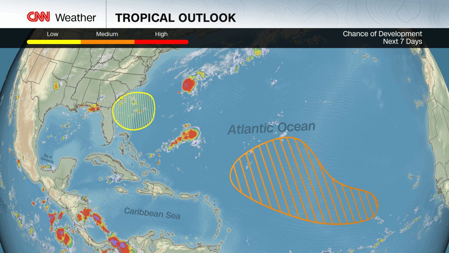
One of these waves just moved off the coast of Africa Monday and has a medium chance of becoming a tropical depression or tropical storm later this week as it tracks west through the main development region, according to the NHC.
There’s another spot to watch for tropical trouble right off the southeastern US coast. Low pressure could form in this region later this week and has a low chance to gradually develop into something tropical, according to the NHC.
Outside of these areas, there’s still too much uncertainty and too many unknowns to make any detailed predictions for the coming weeks. Not every tropical wave that comes off Africa will develop, and even those that do may struggle depending on the environment they encounter.
But the broader pattern shift is what’s worth watching most closely. The ingredients — warm water, weakening upper-level winds, rising air and more moisture — are starting to come together for sustained tropical development.
All it takes is one storm to change everything, so now is the time to start paying attention.
The-CNN-Wire
™ & © 2025 Cable News Network, Inc., a Warner Bros. Discovery Company. All rights reserved.
CNN Meteorologist Mary Gilbert contributed to this report.


